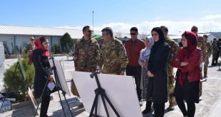
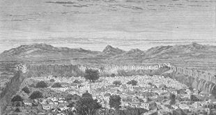
Herat Guide

Herat, Afghanistan

Description This beautifully rendered map of Herat dates from 1880, the final year of the Second Anglo-Afghan War (1878–80). The map depicts Herat’s impressive defenses and its roughly square plan. The southern and most imposing part of the citadel, “the Ark” (from the Persian arg, citadel) remains standing and is …

ادامه مطلب

Herat, Afghanistan 1933

Business hugs the Kandahar Gate at Herat: Vegetable stands, bake ovens, and money-changers’ booths have grouped themselves outside the portal from which starts the south road. They add an air of animation to this, the busiest of the five entrances. The earthwork on which the city wall stands is 50 …

ادامه مطلب

FORD COMMERCIAL IN HERAT, AFGHANISTAN

1958 FORD COMMERCIAL IN HERAT, AFGHANISTAN The 1958 Ford is contrasted with the Afghan horse & buggy. This came part of a catalog documenting a trip that began in Turkey and ended up in Afghanistan (and back as the ad says). The idea seems to be that if this car …

ادامه مطلب

Herat-1880

DESCRIPTION The caption reads in the original French: La citadelle Hérat. Publisher:Paris: La Librairie Illustrée, 1885-1891 Keywords: 1880s, 19th century, Afghanistan, antiquity, Asia, black & white, cityscape, fort, reference book Published in 1885-1891 Nouveau dictionnaire encyclopédique universel illustré By Trousset, Jules (under the direction of) Paris: 1885-1891  

ادامه مطلب

THE RUINS OF THE MASALAH

Sepia-toned photo-lithograph of a wash sketch, showing the remains of the Timurid Musalla before the dismantling. National Archive of India : Foreign Department / Branch: Frontr. B / Nov. 1885 / Ref. No. 44-45, letter of 1st July 1885 from Colonel Sir West Ridgeway, sent to Marquis of Salisbury, Secretary …

ادامه مطلب